Category:Files created by User:Sémhur
Jump to navigation
Jump to search
English: This category contains files created by Sémhur (photos, maps, diagrams and drawings). He is the creator of this version of these files, but not necessarily the creator of all the images sources.
Français : Cette catégorie contient des fichiers modifiés par Sémhur (photos, cartes, diagrammes et dessins). Il est le créateur de ces versions de fichiers, mais pas nécessairement le créateur de toutes les images sources.
Subcategories
This category has the following 2 subcategories, out of 2 total.
Media in category "Files created by User:Sémhur"
The following 200 files are in this category, out of 1,454 total.
(previous page) (next page)-
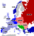
 1959 NATO and WP troop strengths in Europe.svg 655 × 689; 267 KB
-
 1973 NATO and WP troop strengths in Europe.svg 655 × 689; 299 KB
-
 A Elbereth Gilthoniel-teng.svg 1,000 × 900; 117 KB
-
 Abbaye du Ronceray - Angers - 20100801.jpg 8,732 × 3,616; 11.75 MB
-
 Abidjan Communes.svg 593 × 398; 53 KB
-
 Abies beshanzuensis distribution map.svg 1,241 × 1,177; 1.22 MB
-
 Abri de Cro-Magnon - Les Eyzies de Tayac - 20090925.jpg 3,888 × 2,592; 3.7 MB
-
 Abri de la Madeleine - Vue générale - 20090925.jpg 3,888 × 2,592; 2.79 MB
-
 Abri de la Micoque - 20090925.jpg 4,356 × 2,332; 3.7 MB
-
 Abri Pataud - Ibex - 20090922.jpg 3,456 × 2,592; 2.76 MB
-
 Abri Pataud - Les Eyzies de Tayac - 20090922.jpg 6,788 × 3,089; 8.09 MB
-
 Abri Pataud - Protomagdalenian woman skull - 20090922.jpg 3,673 × 1,999; 2.59 MB
-
 Abri Pataud - Reused biface - 20090922.png 1,472 × 1,766; 1.88 MB
-

-
 Accent tonique en breton map-fr.svg 650 × 650; 1.9 MB
-
 Acoma Comtesse - Les Petits Ruisseaux - Back.jpg 3,000 × 4,000; 4.14 MB
-
 Acoma Comtesse - Les Petits Ruisseaux - Front.jpg 3,000 × 4,000; 4.15 MB
-
 Actinote zikani distribution map.svg 1,051 × 1,131; 1.17 MB
-
 Administrative areas of New Brunswick map-blank.svg 2,237 × 2,199; 1.47 MB
-
 Administrative areas of New Brunswick topographic map-blank.svg 2,237 × 2,199; 3.75 MB
-
 Aipysurus foliosquama distribution map.svg 1,984 × 1,780; 1,004 KB
-
 AJ Auxerre - L'équipe idéale 1977-2007.svg 534 × 738; 10 KB
-
 AJ Auxerre - Team 1983-1984.svg 534 × 738; 14 KB
-
 AJ Auxerre - Équipe 1992-1993.svg 534 × 738; 14 KB
-
 AJ Auxerre - Équipe 1995-1996.svg 534 × 738; 15 KB
-
 AJ Auxerre - Équipe 2002-2004.svg 534 × 738; 16 KB
-
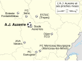 AJ Auxerre et ses clubs voisins map-fr.svg 1,081 × 802; 115 KB
-
 Alcoholmeter- 20091205.jpg 2,393 × 3,589; 3.37 MB
-
 Alemannic language location map in 1950-fr.svg 1,400 × 1,000; 245 KB
-
 Alençon Alto public transport map-fr.svg 1,080 × 1,080; 103 KB
-
 Alps-Mediterranean Euroregion map-ar.svg 1,465 × 1,126; 483 KB
-
 Alps-Mediterranean Euroregion map-de.svg 1,465 × 1,126; 228 KB
-
 Alps-Mediterranean Euroregion map-en.svg 1,465 × 1,126; 344 KB
-
 Alps-Mediterranean Euroregion map-fr.svg 1,465 × 1,126; 344 KB
-
 Alps-Mediterranean Euroregion map-it.svg 1,465 × 1,126; 344 KB
-
 Alsace Lorraine departments evolution map-fr.svg 600 × 450; 98 KB
-
 Alto Magdalena Pipeline administrative map-fr.svg 1,301 × 1,708; 1.13 MB
-
 Alto Magdalena Pipeline physical map-fr.svg 1,301 × 1,708; 1.13 MB
-
 Amanipodagrion gilliesi distribution map.svg 1,549 × 1,475; 1.59 MB
-
 Amilcar Kühlerfigur.png 645 × 768; 286 KB
-
 Amphiprioninae distribution map-blank.svg 1,000 × 500; 2.85 MB
-

-
 Anahim Volcanic Belt-en.svg 2,334 × 832; 723 KB
-
 Anahim Volcanic Belt-ru.svg 2,334 × 832; 815 KB
-
 Ancienne chartreuse de Pierre-Châtel 2015-05-06.jpg 7,140 × 3,570; 12.95 MB
-
 Ancient Egyptians on a small craft - mastaba of Nikauisesi, Saqqara.jpg 1,600 × 1,200; 845 KB
-
 Angers - Château - Cachot des fous - 20080921.jpg 3,888 × 2,592; 3.07 MB
-
 Angers - Château - Cachot Tour 13 - 20080921.jpg 2,592 × 3,888; 2.3 MB
-

-
 Angers - Château - Cheminée monumentale dans l'ancienne salle du trône - 20080921.jpg 3,318 × 2,212; 1.8 MB
-
 Angers - Château - Haute-cour - 20080921.jpg 3,359 × 2,519; 2.15 MB
-
 Angers - Château - Haute-cour vue large - 20080921.jpg 6,244 × 3,122; 4.2 MB
-
 Angers - Château - Intérieur de la chapelle.jpg 3,888 × 2,592; 2.52 MB
-
 Angers - Château - Jardins intérieurs - 20080921.jpg 8,024 × 2,678; 5.61 MB
-
 Angers - Château - La chapelle, le châtelet et les vignes - 20080921.jpg 3,888 × 2,592; 4.04 MB
-
 Angers - Château - Le châtelet, la chapelle et la tour du moulin - 20080921.jpg 2,325 × 1,550; 1.15 MB
-
 Angers - Château - Le logis royal, la chapelle et le châtelet - 20080921.jpg 3,888 × 1,555; 1.49 MB
-
 Angers - Château - Logis du gouverneur.jpg 3,888 × 2,592; 3.12 MB
-
 Angers - Château - Mur de l'ancienne salle du trône - 20080921.jpg 3,888 × 2,592; 4.69 MB
-
 Angers - Château - Vitrail dans la chapelle - 20080921.jpg 2,236 × 3,975; 2.92 MB
-
 Angers - Eglise Saint-Laud - 20080921.jpg 2,524 × 3,844; 2.39 MB
-
 Angers - Église de la Trinité - Crypte - 20080921.jpg 2,592 × 3,888; 2.68 MB
-
 Angers - Église de la Trinité - Crypte 2 - 20080921.jpg 3,888 × 2,592; 3.41 MB
-
 Angers charpentes de la cathédrale 20150613.jpg 2,592 × 1,944; 920 KB
-
 Angers depuis la tour Sud de la cathédrale 20150613.png 7,028 × 3,904; 34.18 MB
-
 Angers Marcé - tour de l'aéroport - 20070421.jpg 2,592 × 3,888; 1.8 MB
-
 Anisolabis seychellensis distribution map.svg 1,045 × 1,254; 1,020 KB
-
 AnnonaMuricata UaHuka 20061114.jpg 2,592 × 3,888; 1.92 MB
-
 Anthony Joseph - 20090716.jpg 1,687 × 2,532; 1,012 KB
-
 Anthony Joseph and the Spasm Band - 20090716.jpg 3,888 × 1,944; 1.92 MB
-
 Antilophia bokermanni distribution map.svg 1,780 × 1,665; 1.71 MB
-
 Antonio Barrera-edit.jpg 291 × 401; 58 KB
-
 Aphanius transgrediens distribution map.svg 1,828 × 1,577; 2.22 MB
-
 Apis andreniformis distribution map.svg 863 × 443; 1.85 MB
-
 Apis cerana distribution map.svg 863 × 443; 1.85 MB
-
 Apis distribution map.svg 863 × 443; 1.85 MB
-
 Apis dorsata distribution map.svg 863 × 443; 1.85 MB
-
 Apis florea distribution map.svg 863 × 443; 1.85 MB
-
 Apis koschevnikovi distribution map.svg 863 × 443; 1.85 MB
-
 Apis mellifera distribution map.svg 863 × 443; 1.85 MB
-
 Apis nigrocincta distribution map.svg 863 × 443; 1.85 MB
-
 Aquitani tribes map-fr.svg 878 × 750; 1.26 MB
-
 Aranui3 in Fakarava 20061106.jpg 3,888 × 2,592; 919 KB
-
 Aranui3 in UaPou 20061108.jpg 2,685 × 1,281; 606 KB
-
 Arbrissel Eglise 20070408.jpg 2,592 × 3,888; 1.88 MB
-
 Arles centre-ville map-fr.svg 1,450 × 920; 209 KB
-
 Arles general map-fr.svg 1,150 × 1,300; 36 KB
-
 Armenian Genocide Map-en.svg 2,574 × 1,264; 464 KB
-
 Armenian Genocide Map-fr.svg 2,574 × 1,264; 518 KB
-
 Armenian Genocide Map-hu.svg 2,574 × 1,264; 501 KB
-
 Armorican Massif geological map-fr.svg 1,770 × 1,300; 981 KB
-
 Arnica Montana Culture In Scotland-fr.svg 1,024 × 716; 513 KB
-
 Arques drainage basin-fr.svg 2,258 × 1,975; 2 MB
-
 Arquipélago das Berlengas-en.svg 1,643 × 2,743; 209 KB
-
 Arquipélago das Berlengas-fr.svg 1,643 × 2,743; 209 KB
-
 Arquipélago das Berlengas-pt.svg 1,643 × 2,743; 209 KB
-
 Arrondissement de Grasse in PACA locator map.svg 2,732 × 2,367; 97 KB
-
 Arshakuni Armenia 150-en.svg 2,717 × 1,595; 850 KB
-
 Arshakuni Armenia 150-fr.svg 2,717 × 1,595; 763 KB
-
 Asinara map.svg 601 × 650; 1.62 MB
-
 Assam protected areas map-blank.svg 2,393 × 1,956; 417 KB
-
 Association Footbal formation 3-5-2 -fr.svg 356 × 492; 17 KB
-
 Association Footbal formation 4-2-3-1 -fr.svg 356 × 492; 17 KB
-
 Association Footbal formation 4-3-3 -fr.svg 356 × 492; 17 KB
-
 Association Footbal formation 5-3-2 -fr.svg 356 × 492; 16 KB
-
 Association Footbal formation 5-4-1 -fr.svg 356 × 492; 16 KB
-
 Atelier Graphique Palette Couleurs Inkscape.png 792 × 616; 63 KB
-
 Atelopus balios distribution map.svg 1,499 × 1,511; 1.63 MB
-
 Aube regions map-fr.svg 540 × 394; 78 KB
-
 Aurignacian culture map-fr.svg 720 × 540; 90 KB
-
 Auroch - Laugerie Basse - Les Eyzies de Tayac - MNP.jpg 3,567 × 2,377; 2.81 MB
-
 Aurochs - Fourneau du Diable - Bourdeilles - MNP.jpg 3,888 × 2,592; 3.87 MB
-
 Aurora's drift map-fr.svg 1,560 × 1,264; 415 KB
-
 Aztec Empire 1519 map-fr.svg 1,898 × 1,462; 303 KB
-
 Bafokeng flag.svg 1,000 × 500; 23 KB
-
 Bagratuni Armenia 1000-fr.svg 2,717 × 1,595; 815 KB
-
 Bahrain map-fr.svg 1,170 × 1,575; 687 KB
-
 Baie de Hakahau.jpg 12,816 × 1,716; 4.25 MB
-
 Baie des Cochons locator map.svg 851 × 344; 623 KB
-
 Banner Labuan Banten.jpg 13,802 × 1,983; 12.54 MB
-
 Barcelona Barris map.svg 1,900 × 1,050; 325 KB
-
 Barcelona Districts map.svg 1,102 × 992; 182 KB
-
 Basin of Mexico 1519 map-en.svg 1,412 × 1,883; 526 KB
-
 Basin of Mexico 1519 map-es.svg 1,412 × 1,883; 526 KB
-
 Basin of Mexico 1519 map-fr.svg 1,412 × 1,883; 528 KB
-
 Battle of Poitiers 1356 map-en.svg 1,704 × 1,467; 1.64 MB
-
 Battle of Poitiers 1356 map-fr.svg 1,704 × 1,467; 1.63 MB
-
 Battle of Quiberon Bay - 1759 - Tracks map-en.svg 670 × 912; 125 KB
-
 Battle of Quiberon Bay - 1759 - Tracks map-fr.svg 670 × 912; 127 KB
-
 Battle of Quiberon Bay - 1759-11-20 - map-fr.svg 1,820 × 1,265; 790 KB
-
 Battle of Red Cliffs 208 extended map-en.svg 782 × 591; 762 KB
-
 Battle of Red Cliffs 208 extended map-fr.svg 782 × 591; 755 KB
-
 Battle of Red Cliffs 208 map-en.svg 843 × 480; 718 KB
-
 Battle of Red Cliffs 208 map-fr.svg 843 × 480; 710 KB
-
 Battle Trebia-en.svg 999 × 755; 96 KB
-
 Battle Trebia-fr.svg 999 × 755; 94 KB
-
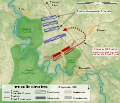
 Battle Trebia-numbers.svg 999 × 755; 92 KB
-
 Bentley 4½ Litre - 20090924.jpg 3,888 × 2,592; 2.47 MB
-
 Bentley 4½ Litre - Back side - 20090924.jpg 3,358 × 2,519; 2.3 MB
-
 Bentley 4½ Litre - Front side - 20090924.jpg 3,888 × 2,592; 2.73 MB
-
 Bentley 4½ Litre - Handbrake - 20090924.jpg 2,354 × 3,531; 1.58 MB
-
 Bentley 4½ Litre - Right side - 20090924.jpg 3,852 × 1,926; 2.47 MB
-
 Berlengas-en.svg 1,500 × 1,219; 193 KB
-
 Berlengas-fr.svg 1,500 × 1,219; 193 KB
-
 Berlengas-pt.svg 1,500 × 1,219; 193 KB
-
 Beynac et son château - 20090926.jpg 3,888 × 2,592; 5.37 MB
-
 Bisons - Les Jamblancs - Bourniquel - MNP.jpg 3,723 × 1,862; 2.45 MB
-
 Bissy 1921 map.svg 968 × 726; 108 KB
-
 Bjornoya Location Map-blank.svg 1,010 × 1,267; 213 KB
-
 Bjornoya Location Map-en.svg 1,010 × 1,267; 242 KB
-
 Bjornoya Location Map-fr.svg 1,010 × 1,267; 242 KB
-
 BlankMap-World 1959.svg 940 × 477; 794 KB
-
 Bobo doll-en.svg 1,000 × 1,000; 9 KB
-
 Bobo doll-fr.svg 1,000 × 1,000; 9 KB
-
 Bobo doll-gu.svg 1,000 × 1,000; 9 KB
-
 Boistrudan.jpg 2,176 × 469; 208 KB
-
 Bombarde - Château de Castelnaud - 20090926.jpg 3,888 × 2,592; 1.99 MB
-
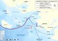
 Bosphorus – Bridges and Marmaray in Istanbul.JPG 515 × 599; 303 KB
-
 Bosporan Kingdom growth map-fr.svg 675 × 575; 1.13 MB
-
 Boundaries in the Arctic - map-fr.svg 1,335 × 1,335; 969 KB
-
 Bresle Drainage Basin-fr.svg 1,024 × 717; 308 KB
-
 Bresle.jpg 1,490 × 1,620; 1.13 MB
-
 Le Bugue - Église Saint Sulpice - Vitrail de Saint Joseph - 20090924.jpg 2,554 × 3,831; 3.82 MB
-
 Burins and blades - Bernifal - Meyrals - MNP.jpg 2,334 × 3,113; 2.34 MB
-
 Button Icon Black.svg 300 × 300; 2 KB
-
 Button Icon Blue.svg 300 × 300; 2 KB
-
 Button Icon BlueSky.svg 300 × 300; 2 KB
-
 Button Icon Brown.svg 300 × 300; 2 KB
-
 Button Icon Cyan.svg 300 × 300; 2 KB
-
 Button Icon Fuchsia.svg 300 × 300; 2 KB
-
 Button Icon Green.svg 300 × 300; 2 KB
-
 Button Icon GreenBlue.svg 300 × 300; 2 KB
-
 Button Icon GreenForest.svg 300 × 300; 2 KB
-
 Button Icon GreenYellow.svg 300 × 300; 2 KB
-
 Button Icon Lime.svg 300 × 300; 2 KB
-
 Button Icon Orange.svg 300 × 300; 2 KB
-
 Button Icon Pink.svg 300 × 300; 2 KB
-
 Button Icon Purple.svg 300 × 300; 2 KB
-
 Button Icon Red.svg 300 × 300; 2 KB
-
 Button Icon Turquoise.svg 300 × 300; 2 KB
-
 Button Icon Violet.svg 300 × 300; 2 KB
-
 Button Icon White.svg 300 × 300; 1 KB
-
 Button Icon Yellow.svg 300 × 300; 2 KB
-
 Bèze river map-fr.png 594 × 594; 507 KB
-
 Béarn topographic map-fr.svg 1,608 × 1,600; 2.57 MB
-
 Cabezo de Alcalá aerial view-fr.svg 1,577 × 1,018; 137 KB
-
 Cacao species - World distribution map -blank.svg 800 × 400; 1.27 MB
-
 Caesar campaigns gaul-en.svg 751 × 777; 201 KB
-
 Calaisis 1360 map-fr.svg 1,424 × 892; 773 KB
-
 Campagne avant la bataille de Poitiers 1356.svg 450 × 550; 40 KB
-
 CanadaBannerNew-fr.gif 468 × 60; 10 KB
-
 Cantons de Cannes.svg 2,283 × 1,545; 307 KB
-
 Carte administrative des Provinces Maritimes du Canada.svg 2,928 × 2,106; 900 KB
-
 Carte communes nouvelles Maine-et-Loire 2015-2017.svg 1,197 × 936; 5.18 MB
-
 Carte de la Bèze.svg 1,395 × 2,790; 3.02 MB
-
 Carte des attaques du Monstre du Valais-fr.svg 1,719 × 1,290; 538 KB
-
 Carte des domaines de Chōshū, Saga, Tosa et Satsuma.svg 570 × 570; 1.94 MB
-
 Carte des pierres à cupules de Billème.svg 750 × 750; 359 KB
-
 Carte des terroirs de bagadoù lors du concours 2008.svg 1,064 × 786; 168 KB
-
 Carte des terroirs de bagadoù lors du concours 2009.svg 1,064 × 786; 172 KB


_(Amsterdam_and_Saint-Paul_centered).svg)


